For service in the Atlanta, Georgia area contact or call us:
- Home
- Accident Reconstruction
- Scene Mapping
Scene Mapping
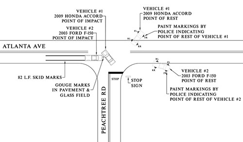
Atlanta Engineering Services, Inc. offers scene mapping and land surveying services to document and gather evidence at the scene of an accident. Scene mapping is the process of taking measurements, collecting data and illustrating evidence on a scaled drawing of the roadway. Drafting personnel prepare the drawings using Computer Aided Design (CAD) programs, such as AutoCAD.
Accident scene diagrams provide the engineers with an overall view of where evidence is located in the roadway in order to reconstruct the accident. In accident reconstruction, the following must occur regarding matching the simulated path of vehicles with scene evidence:
- the simulated path of a vehicle must match the skid marks on the roadway
- the vehicles come together at the point(s) of impact and all damage is documented
- the vehicles must stop at its point of residential scene evidence specific to the accident must be taken into account
Scene mapping depends on the type of accident that is being mapped, whether there are any roadway defects, roadway design flaws and roadway maintenance issues.
Hydroplaning Accidents
Hydroplaning accidents are one example in which these situations come into play. The geometry of the roadway is of particular concern. The roadway is surveyed and elevation data collected to prepare a topographic survey showing the slope of the roadway, drainage patterns, and existing stormwater systems.
The engineer analyzes the scene map to determine whether hydroplaning contributed to the cause of the accident.
Scene maps are also used to create surface models for 3-D Accident Simulation Videos.
Creating simulations is an iterative process in which multiple simulations are ran until the simulated path of vehicles corresponds with scene evidence, vehicle crush damage and other evidence. Using a site specific roadway environment in a simulation is critical in creating an accurate simulation, making scene maps ever so important.
Below is a sample scene map that was put together for a two car accident where a 2009 Honda Accord failed to yield the right-of-way when making a left turn.

Related Information about Traffic Accident Reconstruction
|
Collision analysis in 10 steps The accident scene investigation Atlanta Engineering Services, Inc. offers scene mapping... read more here Learn how a vehicle black box and it's downloads can prove up evidence View a sample engineering report here Why you need an expert witness Calculating the stopping distance Multiple surfaces calculator to determine the stopping distance when there is more to consider. Vehicle speed calculator |
Accidents involving motorcycles How a vehicle inspection analysis can help you after an accident Reconstructing accidents involving Non-Commercial trucks Read how vehicle defects can be the cause of a traffic accident here. It just may be those roadway ruts that caused you to hydroplane, find out more here Was it poor design or layout that caused the accident? See real 3D accident simulations with this link More 3D accident reconstruction videos can be found here See actual photos of traffic accidents here |
