For service in the Atlanta, Georgia area contact or call us:
Topography Surveys
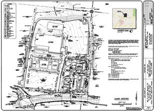
A topography survey provides a graphical representation of the lay of the land. It shows both natural and man-made features using contour lines and elevation points. Contour lines are curved or straight lines that connect points along the same elevation. Elevation points have an x, y, z coordinate and are used to create the contours lines using advanced 3-D computer modeling programs such as AutoCAD Civil 3D. Surface models of the terrain are created in 2-D or 3-D and are used to determine the slope of the ground.
 |
 |
View Full Size PDF of Boundary / Topographic Survey
Topography surveys typically include the following items on the drawing:
- Property lines with bearings and distances
- Improvements such as buildings, driveways, sidewalks, parking lots, fences, retaining walls, swimming pools, aboveground evidence of utilities, etc.
- A portion of the roadway in which the property has frontage.
- Easements (i.e. Utility easements, storm drainage easements, driveway access easements, sanitary sewer easements, etc.)
- State waters such as creeks, streams, rivers, ponds, lakes, etc.
- List the FEMA Flood Insurance Rate Map designation for whether the property is in a flood zone.
- Contour lines labeled with its corresponding elevation
- Finish floor elevations of buildings
- Top of manhole elevation, invert elevations of pipes, pipe diameters and type of materials for stormwater and sanitary sewer pipes.
Topography surveys enable engineers to design buildings with their respective utilities, determine stormwater drainage patterns, determine flood plain limits, determine the volume of an existing detention pond, determine how much cut or fill dirt is required during excavation to minimize excavation costs, etc.
A topography survey is the ideal solution for most all construction projects. For projects requiring more in-depth title research, please refer to the ALTA / ACSM Land Title Survey which also offers topographic information.
For Additional Information Go To:
Home Page - Atlanta Engineering Services
What you need to know before you hire Land Surveyors
View a sampling of our completed projects here
Understanding property boundaries
Do you need an ALTA or ACSM survey?
Atlanta Engineering provides Topography Surveys
Liquor License and Beer and Wine Surveys
