For service in the Atlanta, Georgia area contact or call us:
ALTA-ACSM Surveys
in Georgia
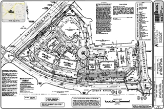
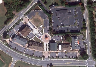
The ALTA ACSM Survey or The ALTA/ACSM Land Title Survey are surveys of real property that are made for the insured client, title company and lender for issuing title or mortgage insurance. These surveys are usually requested by commercial property owners.
The purpose is to make certain that the property is free and clear of survey issues. This involves comparing the information surveyed in the field to the record information obtained in the title commitment.
Items disclosed on the survey are considered being an "exception" and are excluded from the title or mortgage insurance policy.
Land Surveying Requirements
for ALTA ACSM Survey
The American Land Title Association (ALTA) and American Congress on Surveying and Mapping (ACSM) have set forth the minimum requirements for the standard level of detail that is shown on an ALTA / ACSM Land Title Survey.
An ALTA / ACSM survey shows the boundary lines, improvements, easements, rights-of-way, water features and other items affecting the property.
Whereas items such as topography / contours, flood zone classification, wetlands, exterior dimensions of buildings, parking lot striping, location of utilities, etc are excluded from the minimum ALTA survey requirements.
 |
 |
Because of a need to show these items on the survey, ALTA/ACSM have compiled a table of optional items called "Table A," which includes such items.
We recommend our clients review the items listed in "Table A" and check the additional items they would like to be shown on the survey. This provides the client with a clear understanding of the survey project.
Download a copy of Table A here
ALTA ACSM Survey Standards
In 1962, The American Land Title Association (ALTA) and the former American Congress on Surveying and Mapping (ACSM) developed the standards for the ALTA/ACSM Surveys to clarify and remove the standard survey exceptions from their title policy. They gave it the name ALTA/ACSM Land Title Survey. Since 1962, they have revised the requirements approximately eleven times. It changes to meet the needs of the lending industry and the survey industry.
The surveyor performs the field work, drafting of the survey drawing, calculations, and review of the title documents. Once the surveyor has prepared a completed copy of the survey, a Professional Land Surveyor stamps the survey with his / her seal and signs the survey.
The survey also includes a certification that states that the map or plat and the survey on which it is based were made under the 2011 Minimum Standard Detail Requirements for ALTA / ACSM Land Title Surveys, which includes the selected items of Table A.
The National Society of Professional Surveyors provides information such as "What Surveyors Do," "When You Need A Surveyor," and Surveyors' Professional Qualifications. Its aim is to provide the continuing educations tools needed by surveyors in the changing world of technology.
For Additional Information Go To:
Home Page - Atlanta Engineering Services
What you need to know before you hire Land Surveyors
View a sampling of our completed projects here
Understanding property boundaries
Do you need an ALTA or ACSM survey?
Atlanta Engineering provides Topography Surveys
Liquor License and Beer and Wine Surveys
Call us today.
770-316-1720
Atlanta Engineering Services
918 Holcomb Bridge Road
Roswell, GA 30076
or email us at:
ela@atlantaeng.com

Elvin Aycock, PE, PH, PLS
Professional Engineer
Professional Hydrologist
Professional Land Surveyor
Forensic Services
- Hydrology
- Hydroplaning
- Storm Runoff Damage